I was recently involved in a GIS Health Check for one of our clients, Carbon Neutral, who wanted to get an outside perspective on ways they could improve their data management and spatial software. It was a really rewarding experience on a personal level to explore how another company used spatial information, but also I think we were able to give them some recommendations that will deliver benefits to their business.
A GIS Health Check involves a process of investigation and discovery of an organisation’s Geographic Information System. It includes a set of stakeholder interviews coupled with a hands-on exploration of the GIS data and software. It also considers other aspects of the broader system environment; but, at the end of the day, what are the benefits of a GIS Health Check?
Well, let me explain by giving you an example.
Think of the uses your company makes of spatial information. Can you identify any pain points, or areas where you think things could be done more effectively? Throughout the process, these are the key business problems we want to come back to, to ensure that whatever is recommended, is aimed at delivering real benefit and value. These may be things that jump out straight away in interviewing stakeholders, or they may be more stealthily embedded issues that need more analysis and thinking. Before we think about the solution, it is critical that the GIS Health Check identifies the problems that need to be solved.
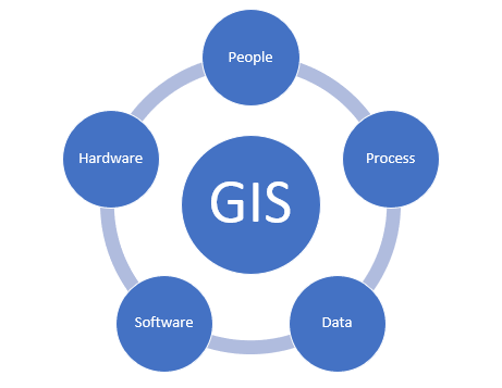
During a GIS Health Check, we consider five elements: People, Processes, Data, Software and Hardware. When these elements are appropriately resourced and working together effectively, we can say we have a healthy GIS system. However, if one (or more) element is not operating efficiently, or is lacking focus in the organisation, there are problems in the organisations’ workflow.
Each organisation has a different aim when requesting a GIS Health Check. For some, a major issue is about historical data management and a resulting lack of structure in the database system (e.g. layer naming, authoritative sources, accessibility). Others might be more interested in improving their processes, writing documentation on them and making sure all the GIS stakeholders are aware and brought into a consistent framework. There are companies that think the software they are using might not be the best fit for their work, or that alternative products may be available that will deliver better value and efficiency. Most of the time, it is a combination of issues from the different elements.
So when it comes down to an individual GIS Health Check – what do we at Gaia Resources actually do? Even though the objectives are different for each organisation, the approach is pretty much the same. We start by checking the current state of the system: we interview all the GIS users in the company, in order to identify what is working well and where are the ongoing issues. We also get inside your system to ‘lift the hood’ and evaluate the organisations’ spatial data and how it is organised, checking for duplicate files, naming conventions and degree of adoption, folder structures, software used, key business processes supported by spatial information, and many other aspects.
We also tap into the knowledge of the organisation’s stakeholders, to understand the business context, related strategy objectives and to gain an understanding of how staff think their Geographic Information System should evolve. Basically, what does the future state look like?
Based on our review of the current and desired future state, we put our thinking caps on to brainstorm and provide recommendations. These are meant to improve the future state of the company’s GIS environment, and provide tangible strategies and actions for getting there. The recommendations are classified in terms of priority, estimated effort and category (e.g. the 5 GIS environment elements covered above).
Gaia Resources has conducted a significant number of these GIS health checks over the years, as mentioned in this blog. Some of our clients are IGO, Redbank Copper, MBS Environmental, OEPA and recently, Carbon Neutral. We keep in touch with these organisations, and with some we continue to support them with QGIS training and software development.
Having been through the process, and really benefiting from the previous GIS Health Checks deliverables, I took a page out of our own book so to speak and developed a guideline on “How to deliver a GIS Health Check.” We reviewed previous projects and identified all the common points for a successful Health Check. That guideline is now a resource for our Data Science team and project managers who will no doubt be helping more organisations in the future.
To summarise (and answer my first question), having your GIS checked can bring many long-lasting benefits, from improving workflow efficiency and consistency, to enhancing decision making and building capabilities in your team. We help organisations achieve this by working with them to focus on the key business challenges where spatial information can play a role.
If you think the GIS environment in your organisation could do with a review, reach out and start a conversation with us via email, or through our social media platforms – Twitter, LinkedIn or Facebook. We are here to help!
Rocio


Comments are closed.